The excellent article on the vulnerability of the Deer Isle causeway (The Working Waterfront, November issue) prompts me to add some history, as well as some things to consider when planning future modifications.
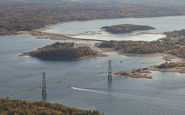
Before the causeway was built, passage between Deer Isle and Little Deer, unless by boat, was at low tide across what was known as Scott’s Bar. This was not a true sand bar, but rather a sinewy line of hard clay that was slightly higher than the surrounding clam flats. Its snakelike pattern, retained by the present causeway, was the product of winds, waves, and currents.
As early as 1873, and again in 1875 and 1880, the town appropriated the sums of $50 to fill a low spot in the bar near Little Deer. Not until the 1920s, however, was serious thought given to construction of a causeway. The thinking was that if ever a bridge was to connect Deer Isle to the mainland, it would have to be from Little Deer across the narrowest part of Eggemoggin Reach. But without an all-tide connection to Deer Isle across Scot’s Bar, raising money for a bridge would be difficult.
Up until the 1930s, the gap between Deer Isle and Little Deer was an important fish passage…
George E. Snowman of Little Deer, who was in the legislature, was able to get $15,000 from the state to begin construction of the causeway in 1927. Over the next ten years, further appropriations enabled work to continue. At first, stones were placed along the edges of the hard clay bar. As the years wore on, its height was built up until, in 1938, one could cross it at any tide. Because it followed the natural course of the hard clay, rather than crossing soft mud, it was based on a firm foundation
The causeway remained a town road until 1946, when the state was persuaded to take over full responsibility for its upkeep. At that time, the Little Deer approach was straightened and Pine Hill (on Little Deer) was quarried for stone to widen and raise the road’s height. This was perfectly adequate until the current era of overpowered, bloated cars, SUVs, and monster trucks (not to mention increased traffic).
Up until the 1930s, the gap between Deer Isle and Little Deer was an important fish passage, which attracted the interest of Wabanaki Indians. Here, they built fish weirs, speared flounders, and dug clams. Interestingly, when the first colonial settlers arrived (in 1762), they did the same thing: built fish weirs, dug clams, and speared flounders.
The importance of the place for the Wabanakis was reflected in two names for it: “Where the Fish Weirs Are” (the word Eggemoggin is a corruption of the Indian word) and “At the Great Fish Weir.” Also indicative is a concentration of ten known Wabanaki campsites nearby, some including material as many as 3,000 years old to as recent as the early years of colonial activity.
A final reflection of the importance of this place is that it was chosen in 1726 for a meeting between Penobscots and colonists in an attempt to end one of several conflicts as Wabanakis defended their homeland from European incursions. In exchange for the Penobscots laying down their arms, the colonists sent a sloop filled with trade goods as well as Indian captives for repatriation.
The gap where the causeway runs today was also an important transportation route. An Indian canoe route ran through here, from the small cove in Brooksville known as the Punch Bowl, across the Reach and along the Deer Isle shore to a portage to Long Cove. From the Punch Bowl, a portage led to Walker’s Pond and the Bagaduce River and ultimately the Penobscot River. This canoe route remained in use from 3,000 years ago well into the 20th century.
Once white settlers arrived, they also used this gap on the high water as a shortcut from the western bay to the Reach. One craft attempting this passage, in April 1859, was a whaleboat rigged as a sloop called bowcat (bow rhymes with oh). Enroute from Northwest Harbor to the Benjamin River loaded with hoop poles, it was crossing Scott’s Bar when the wind shifted, driving it on to the Little Deer Isle shore. From this incident, came the transfer of the vessel’s name to the body of water between Little Deer, the Causeway, Carney Island, and the facing shore of Deer Isle.
Given the historical and ecological importance of the causeway’s location, any alteration of this structure should restore the free flow of water between the Reach and Western Bay. When the causeway was completed, it blocked not only passage of watercraft, but of fish as well. Within a few years, the flounders were gone, and the last fish weir was built in 1950.
At the Sept. 20 meeting on the causeway, reported on by The Working Waterfront, Marsden Brewer of Stonington spoke of the potential benefit of restoring the flow of water for the scallop fishery. We know scallops were present on the bay side in the past, as there was a midden of scallop shells (now eroded away) on Carney Island.
And I recall in the 1950s someone hooking up significant numbers of scallops on the Reach side.
Clearly, something has to be done about the causeway in the face of climate change. We should take the opportunity to do it right!
William A. Haviland is a retired anthropologist and past president of the Deer Isle-Stonington Historical Society. He lives on Deer Isle not far from the causeway.