Revolutionary War-era patriots once captured a British sloop, the H.M.S. Margaretta, in Machias Bay, then sailed the vessel high up the Middle River, hiding it there near the abundant salt grasses which attracted settlers to Machias in the first place.
Today, a dike and causeway span the point where the Middle and Machias Rivers meet, making the Middle River off-limits to enemy ship stashing. That lack of ship passage is OK, but federal officials this year stated the Middle River must be more accessible to migratory fish, sending a replacement plan ten years in the making back to the drawing board.
Now, the town of Machias, the Downeast Salmon Federation, and Maine Coast Heritage Trust say they have a shared vision that could check state, federal, and environmental boxes while checking one for the Machias community, too. No matter what the dike replacement looks like, they say, it should not only improve fish passage, but preserve the dike’s unique cultural and economic value, as well.
On weekends, the dike becomes a linear country fair, with craft, food, and farm vendors parked…
Everyone who drives Route 1 along the Downeast coastline passes over the Machias dike, or just “the dike” as it is affectionately known by locals. Wide for a bridge, the dike holds more than just Route 1 and the recreational Down East Sunrise Trail. It also holds a generous parking area where, on weekends, the dike becomes a linear country fair, with craft, food, and farm vendors parked between a food truck or two, with a steady stream of pedestrians browsing.
This hum of activity is one part of what makes the Machias dike project more than just an infrastructure project, says Maine Coast Heritage Trust Project Manager Jacob van de Sande.
“It’s much more than that. This would be one of the largest salt marsh restorations in the state of Maine,” says van de Sande. “But there’s also economic development. The dike is an important part of this community’s economy.”
In March, Maine Department of Transportation held a month-long public hearing—online due to COVID-19—collecting feedback on a dozen replacement scenarios ranging from adding more culverts to building an open bridge.
That won’t work for us, says Bill Kitchen, Machias interim town manager. And he believes DOT is listening.
“From our discussions, I believe the DOT recognizes their responsibility to not only preserve but improve the economic and cultural value the dike brings to this community,” said Kitchen. “The town’s role is quite simply to make this rebuild as good as it can be. It’s going to happen, the question is, what will it look like?”
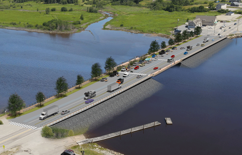
An artist’s rendering shows exactly what the town and its nonprofit partners hope the dike will look like. In the drawing, a new row of trees stands between the roadway and the gravel Sunrise Trail, with a broad vendor area stretching the length of the bridge, now fully open to allow water to flow beneath it. On the other side of Route 1, a protected pedestrian walkway runs along the roadway, with a designated observation deck above the bridge’s opening, where walkers could enjoy the view of the Machias River.
“There’s never been a better time to fund a project like this,” says van de Sande, pointing to recent federal infrastructure investments. “It’s a unique situation because it checks all the boxes—climate resiliency, economic development, community health, and environmental restoration.”
Maine Coast Heritage Trust and Downeast Salmon Federation are particularly interested in salt marsh restoration, which could take place if full tidal action were restored between the Middle and Machias rivers. DSF, a nonprofit dedicated to rebuilding endangered Atlantic salmon populations, is currently restoring the Schoppee Salt Marsh, just around the corner from the Machias dike.
DSF Habitat Restoration Project Manager Charlie Foster says the next five to ten years could bring transformation to Machias.
“I think it would be a change for the better,” said Foster. “We have to show people that you have to ask for these things, and you have to be vocal for what you want. And if you want vendor space, you have to speak up, and we have.”
Other voices will be speaking up, too, at a DOT public hearing scheduled for Sept. 14 in Machias (after publication) to be held outside on the Machias dike, in view of the childhood home of Hannah Rice, which stands on the banks of the Middle River. Should DOT choose a bridge, her family could lose much of their land.
“My family stands to lose over 60 acres that have been in my family for generations, and others stand to lose even more, all because a few want to make passage for a few fish that still get into the Middle River through the current [tidal gate] system,” says Rice. “My parents’ yard would be replaced with floodwaters at high tide and rotting plant life and mud at low tide.”
The wide causeway and span idea grew out of plans to provide flood protection for low-lying Machias by way of a seawall.
Project adviser Dr. Tora Johnson, who runs the University of Maine at Machias GIS lab, says any replacement must be built higher than the current dike, because flooding events previously expected to occur once every 100 years are now occurring more often—in the past six years, there have been four, including one in 2019 that overtopped the dike and washed out sections of the Downeast Sunrise Trail.
“We can do nothing, we can leave the dike as it is, but nature will solve the problem of the dike if we don’t do anything,” said Johnson.
Whether it’s a causeway or a bridge, Kitchen says any dike replacement must support the Machias area’s future success.
“I want us to be the poster project for how construction like this can impact the revitalization of a rural coastal town,” he says. “There is tremendous economic value on the dike, and I’m not only talking about the vendors’ receipts. The economic value is about our quality of life, it’s about landmark pride, it’s about community pride, and it’s in the visual impact the dike could have for people who are driving through this community.”