By Tom Groening
The sunny, vacation-vibe we associate with beaches was doused like a pelting thunderstorm at the 12th Beaches Conference in Kittery on June14. Instead of swimming and sunbathing, the gathering addressed the dire realities of sea level rise, unprecedentedly big storms, and dying marshes.
“Why invest in Main Street if it’s going to be underwater?” asked Andy Dorr, Vinalhaven’s town manager, as he described at the conference’s opening the steps the island community is taking to prepare for that grim prognosis.
In 2015, the town formed a sea-level rise committee, which held public meetings and developed a check list of issues to consider.
“The check list gets you to think about risk and vulnerability,” he said. On the island, it’s more than the harbor-front Main Street that rising waters will impact. Bridges and roads across the island also are vulnerable, Dorr said.
The town’s work brought changes to ordinances, the comprehensive plan, and capital improvement budgets.
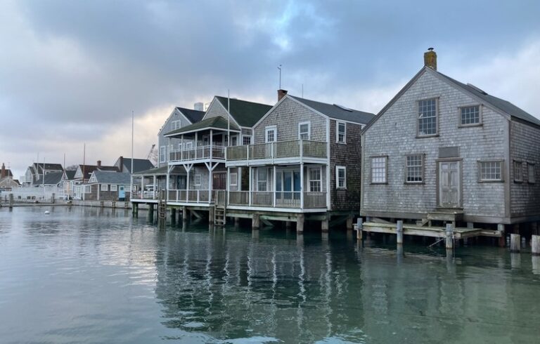
Another victim of rising seas, which may have escaped general notice, is our cultural history. Rodney Rowland of Portsmouth, N.H.’s Strawberry Banke Museum, talked about the impact flooding was having on some of that city’s early 17th century buildings.
“Our history is going underwater. Water is everywhere now,” he said, as he displayed slides showing the basement of one of the historic buildings flooded from an especially high tide. Standing water inside—salt and fresh—and outside at the sills of the old houses, along with lingering high humidity are taking their toll, Rowland said.
Though remediation has been achieved by pouring concrete floors in basements and sealing the outside of foundations, the question remains: “Do choices have to be made as to what cultural resources are preserved?”
The museum is raising $500,000 to address predicted impacts from rising seas.
Climate change also is affecting the animal world on the Maine and New Hampshire coasts.
Sarah Perez of the Seacoast Science Center in Rye, N.H., who helps rescue seals—harp and hooded seals, which visit in winter, and harbor and grey seals, which live there year-round—said the animals have been observed eating sand, trying to get hydrated, because of the lack of freshwater ice on the shore.
Gabriela Bradt of the University of New Hampshire described the impact invasive green crabs are having. The crabs can eat up to 40 softshell clams a day, and also consume eel grass, which results in the collapse of the muddy banks of estuaries.
SHIFTING SHORELINES
Those shifting shorelines were the subject of a break-out session at the conference, at which presenters discussed specific fixes and delineated “living” shorelines from “hard” fixes.
Kirsten Howard of New Hampshire’s Coastal Program described a pilot program at Wagon Hill Farm in Durham. The city purchased the farm on the Oyster River in 1989, and has been addressing erosion issues.
Instead of a rip-rap, or rock wall on an upper bank, as has been done before, “Let’s think about a living, flexible, flood-resistant shoreline,” she said, which includes “putting back the marsh that might have been there before.”
Marshes absorb storm and tide surge and limit erosion; New Hampshire is projected to lose as much as 95 percent of its salt marshes, she said.
Seawall construction will be banned, Howard said, unless it is the only option protecting public infrastructure.
Gregg Moore of the University of New Hampshire explained his work investigating the death of beach grass on his state’s coast. The cause was believed to be microscopic nematodes feeding on the roots, leaving what looked like the remnants of a bonfire after a die-off. But subsequent study revealed the worms were present in both dead areas and where healthy grass grew.
Moore and his students experimented with soil amendments, using lime in some places, grass fertilizer in others, and both in still other areas. The results showed that combining lime and off-the-shelf fertilizer helped sustain the important beach grass, and he is encouraging those who live near dunes to apply this mix.
Alison Sirois of Maine’s Department of Environmental Protection explained how in her state, “living shorelines,” including one in Maquoit Bay, are being built with bags of oysters, secured with oak stakes. Logs laid perpendicular to the shore allow ice to slide up, so as to not destroy the structures.
REAL ESTATE IMPACTS
Erika Spanger-Siegfried of the Union of Concerned Scientists noted that 40 percent of the U.S. population lives on just 10 percent of the country’s land—the counties that touch salt water. “We put all this stuff here because we thought we understood the risks,” she said, yet sea levels have risen by 7 inches since 1900. In Norfolk, Virg., the seas have risen 8 inches since 1970.
The result is what she called “chronic inundation.” By 2045, some 300,000 homes and commercial properties will see “flooding on a chronic basis.” In Maine and New Hampshire, some 3,000 homes and buildings will be affected.
Mike Bellamente of Keller-Williams Coastal Realty of Portsmouth confirmed the obvious: homes under threat of flooding are appreciating in value less than those not under threat. In New Hampshire, that means a loss of $15 million in value; in New England, a total of $330 million in lost value.
Sue Baker of Maine’s Floodplain Management Program noted that “There is no national mandate for flood hazard disclosure” within real estate law. There are 8,200 federal flood insurance policies in Maine.
“That’s way, way, way under-insured,” she said.
What TO Read Next...