DONNA WIEGLE
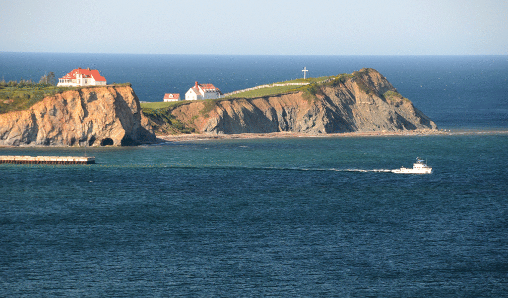
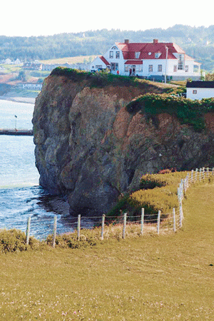
Steep cliffs dominate the scenery.
There’s a saying that goes, “Life is short; take the trip, buy the shoes, eat the cake.” In my case, life is short, so I decided to take the trip.
I’ve been living with advanced stage ovarian cancer since April 2016. Despite the challenges I face each day, I still want to enjoy life and nothing makes me feel more alive than venturing to parts unknown on my Harley Davidson motorcycle.
In mid-August, I left my home on Swan’s Island for a solo motorcycle ride to the Gapsé Peninsula in Québec. I had previously traveled by motorcycle to three of Atlantic Canada’s Maritime provinces—New Brunswick, Prince Edward Island, and Nova Scotia. All offered beautiful scenery and great riding and I expected the same of the Gaspé Peninsula.
Traveling by motorcycle is challenging in many ways. There is limited room for your stuff, so you pack carefully—everything you take must be necessary.
Planning my trip started out no differently than my previous trips to Canada. I got out my map of Atlantic Canada and began to study it. I planned my route and researched the “must-see” sights along the way. As the date for my departure drew near, all the “what-ifs” started to enter my mind. What if it rained? What if I just didn’t have the stamina to ride every day? What if I got sick? I had been admitted to my local hospital just ten days before my departure date for a cancer-related complication, but I was determined to take this trip and to depart as planned.
The day for my departure arrived and I boarded the Swan’s Island ferry headed for what I hoped would be a great adventure. A successful trip would result in an overwhelming feeling of empowerment—that I was in control of my life rather than being controlled by my cancer.
My bike was loaded with everything I thought I might need, including my big Nikon digital SLR camera, which took up a lot of precious real estate inside my small saddlebags. I left things behind so that I could take my good camera, knowing the scenery ahead would be worthy of it.
On the first day, I rode to Van Buren in northern Maine—about 300 miles. I crossed the border into Canada the next morning at St. Leonard, New Brunswick. About 100 miles later, I entered Québec at the Gaspé Peninsula where I traveled east on Route 132. Traveling counter-clockwise around the Gaspé Peninsula gave me a water view on my side of the two-lane road. The miles ticked by and I enjoyed the small towns along Chaleur Bay, an arm of the Gulf of St. Lawrence.
In the afternoon, I reached my destination for the night, and the town of Percé and the famous Percé Rock came into view. The rock, a massive formation just yards off the shore, is 289-feet high, 1,420-feet long, and 300-feet wide.
Located near the rock off the coast of Percé is Bonaventure Island, a Canadian national park and home to the largest migratory bird refuge in North America. About 200,000 birds nest on the island, including 116,000 northern gannets. Daily boat excursions from Percé offer land tours to Bonaventure Island. From my second-floor hotel room overlooking the town of Percé, I had an unobstructed view of the town’s most famous icon, Percé Rock. I spent the afternoon walking around Percé taking pictures of the beautiful coastline of this touristy little town.
As wonderful as I found my time in Percé, the best was yet to come.
I made my way north the next morning toward the city of Gaspé, where I was headed to explore Canada’s Forillon National Park, the eastern most part of the entire Gaspé Peninsula. The park was stunning in its beauty. The road through the park took me through heavily forested areas and back out to coastal water views. Up and down mountain roads and around tight hairpin turns, it was a wonderful experience on a motorcycle.
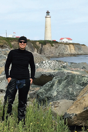
As I made my way along the northern part of Forillon National Park, I encountered Canada’s tallest lighthouse, Cap-des-Rosiers, at 112 feet tall. It marks the turning point from the Gulf of St. Lawrence into the St. Lawrence River, which runs along the northern side of the Gaspé Peninsula.
As I departed the park, I began to head west across the top of the peninsula. The northern part is more rural, but the riding and scenery continued to be spectacular. I climbed mountainous roads and then rolled down into valleys dotted with small towns along the St. Lawrence River.
I turned south at Matane, leaving the St. Lawrence River behind and traveled through Matapédia Valley, an agricultural area surrounded by the Chic-Choc mountains. I spent my last night in the little town of Matapédia, close to the New Brunswick border, a good starting point for my long ride home the following day.
I logged 1,347 miles in five days, arriving home feeling empowered—just what I had hoped for. Next up for me might be to buy the shoes, or eat the cake, or better yet, I think I’ll just take another trip! Remember, life is short.
Donna Wiegle is a member of the board of trustees of the Island Institute, publisher of The Working Waterfront.
DONNA WIEGLE
Standing in front of Cap-des-Rosiers Lighthouse at the edge of Forillon National Park in Gaspé, Québec. It’s Canada’s tallest lighthouse at 112 feet.