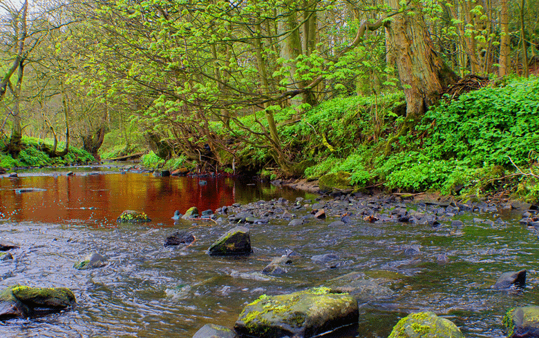
In June, which turned out to be one of the hottest and driest on record, we paddled to a beaver dam on the St. George River just north of Round Pond in Union. The banks rose above us covered in sedges and grasses, bringing our focus to the slow-moving water, the muskrat holes carved in the steep muddy banks, and turtles sunning themselves on logs. We floated for a minute at the dam, which was then more than a foot above the water level, before turning back.
A month later, after one of the wettest Julys on record, we paddled the same waterway. As we floated over a riffle on the surface where the dam lay a foot below the water I thought, “We must be out of the drought now.” But during the evening news, the weather reporter mentioned the ongoing drought. It made me curious.
Maine State Climatologist Sean Birkel, who is a research assistant professor at the University of Maine Climate Change Institute, explained that drought is more complex than just how much rainfall we’ve gotten. Precipitation amounts, soil moisture, streamflow, and groundwater levels are all factors.
Maine’s statewide annual precipitation has increased by 6 inches since 1895.
There are three types of drought: meteorological, agricultural, and hydrological. Meteorological drought refers to when there is less rainfall than usual. There is a net loss of moisture throughout the region.
Agricultural drought happens when there isn’t enough water in the soil to meet plant needs. They start to wilt, brown, and die. Growth is stunted, so farmers don’t get as much hay from the same acre as they do when the plants get enough water.
The third classification is hydrological drought, when streamflow and groundwater levels are low. It takes longer for water deficiencies to show up but when they do, wells run dry, and the levels of ponds, wetlands, and rivers are significantly reduced.
“An end to a meteorologic drought could technically be seen if there is a return to normal precipitation,” Birkel explains.
“But if the dryness persists into another year, it could take a long time for groundwater levels to get back up to normal to end a hydrological drought.”
Normal for a particular region depends on the average rainfall, cloud cover, wind speed, and soil moisture over time. By knowing what to expect, climate scientists can see outlier events like drought. But when outliers happen frequently, the gauge for what is normal changes. Western states have had reduced rainfall for so many years that drought is becoming the new normal. Rainfall averages year over year are falling.
Dr. Birkel was reassuring.
“The Northeast region sometimes sees short-term droughts lasting weeks or months,” he said, but often, not years-long.
There are instances of drought in the historical record, but multi-year droughts with major impacts like the drought in the mid-1960s are rare. The Northeast is at the confluence of the Arctic, Pacific, and Atlantic air masses which help create weather patterns with plentiful rainfall
“July’s beneficial rainfall, for example, brought conditions back to normal across much of coastal Maine and inland Downeast, even though drought conditions had developed after a warm winter with less than normal snowfall, early spring runoff, and a drier than average June,” Birkel explained.
Climate scientists use different tools and timelines to track and measure a drought. The Palmer Drought Severity Index estimates relative dryness using temperature and precipitation data. The Standardized Precipitation Index accounts for rainfall totals over a set period (for example three, five, or 12 months) in relation to historical normal. The Standardized Precipitation-Evapotranspiration Index accounts for surface evaporation, plant transpiration, as well as precipitation.
And there are useful maps from the U.S. Drought Monitor (droughtmonitor.unl.edu) which show precipitation, stream flow, and ground water data paired with on the ground observations.
Maine’s statewide annual precipitation has increased by 6 inches since 1895. Climate models project Maine continuing to become warmer and wetter with more extremes such as heavy precipitation events.
Next month, the beaver dam may still be under water, or the beavers may have built it higher, but now I know a little bit more about the complex systems that are behind the rising and falling river.
For more information on Maine’s climate future, check out the Maine Climate Office website (mco.umaine.edu) for access to historical climate data, weather forecasts, and climate information.
Kate Tagai is a senior community development officer with the Island Institute, publisher of The Working Waterfront. She may be reached at ktagai@islandinstitute.org.