Boothbay Now and Then: New and Historic Images of the Boothbay Peninsula
By Kevin Johnson (2026, Penobscot Marine Museum)
Photographer Kevin Johnson’s new book, Boothbay Now and Then, is a selection of photos depicting the Boothbay region. This subject matter is attractive enough for anyone interested in Maine’s coast. But the book digs a little deeper than that.
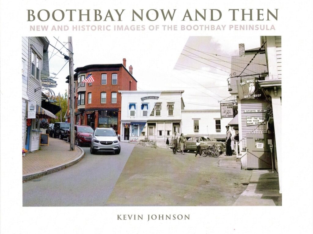
Half of the photos were made during the last couple of years by Johnson, photo archivist at the Penobscot Marine Museum, and the other half were made by photographers for the Eastern Illustrating and Publishing Co. of Belfast about 100 years ago. The EIP, from around the turn of the century through World War II, made scenic postcards from photos. Johnson’s mission, at the prompting of Southport preservationist George McEvoy of Boothbay Harbor who died last year, was to show in pictures how the Boothbay region has changed over the past roughly hundred years. It’s kind of a scenic archaeology.
The book sets postcard images side by side with Johnson’s skillfully made recent images of the same places. We discover that upper Townsend Avenue in Boothbay Harbor village has remained much the same over the decades. The Smiling Cow gift shop, its two stories now painted blue and white, is still there, similar to its 1930s presence. The building beside it, now bright red, was the home of The Sportswear Shop. The brick chimneys on both buildings have disappeared by the 21st century.
A beautiful contemporary shot of the harbor from McKown Hill shows a nicely kept green yard, beyond it the dock, sailboats, and a distant tourist ship. The old EIP view is kind of a fossil of the same scene—shipyard structures in the foreground, a much narrower dock, and a few sailboats. The background islands and point across the bay are exactly the same.
Johnson had to excavate, as it were, for some shots. A view of the working waterfront taken from Mount Pisgah around a hundred years ago, for example, shows a few sailboats, the footbridge with its small house right in the middle, industrial wharves and buildings, and a couple of two-masted vessels in the channel. Johnson could not access the site the EIP photographer shot from, so to duplicate the camera angle, he used a drone. The new image shows the footbridge revamped, the evolution of large waterfront buildings, and many more pleasure boats at mooring.
The more things change, the more they stay the same, might be the archaeological lesson. Cottages at Ocean Point and Isle of Springs are still standing, with only superficial changes to vegetation and in some cases renovated dormers. The iconic soldier’s monument which, with the Congregational Church, made up the backbone of Boothbay center, now stands lonely in the Route 27 roundabout, like a vestige of a bygone time.
The archaeology of the scene is ultimately an archaeology of the people who live there. In an old view of the Cozy Harbor House at Southport Island, people are lounging in the yard and socializing on the porch. The house, according to the photo caption, was built originally in the 1700s by the Pierce family.
This is the family of my grandmother, Harriet Pierce, born in Southport, I think, in 1881. Family documents indicate a couple of English Pierces helped finance the Pilgrims’ Mayflower expedition. Later in the 17th century some of them landed in Marblehead, Massachusetts—my father’s hometown, coincidentally I guess—and soon escaped to Southport. Probate documents from the 1970s show my mother’s name in a list of heirs of a deceased Pierce from Southport. I wonder if those are images of my own relatives lounging in that postcard yard.
I don’t think you need direct connections to the Boothbay area to appreciate this book, though. The visual cues to the peculiar hold the past has on us are in the land and the ways people shape it. Clues to a community’s ancestral life are in its bygone forms. Boothbay’s are imaged here artfully and evocatively by Johnson.
Dana Wilde is a former newspaper editor and college professor who lives in Waldo County.