Waypoints: Community Indicators
COMMUNITY INDICATORS FOR MAINE’S COAST AND ISLANDS
Download the full publication here (PDF)
In response to requests from island community members to help them access clear, accurate data and meet local needs for planning and decision-making, we have expanded our biennial publication, formerly Island Indicators, to provide the best available information about local economies, communities, and environments in a simple, easy to use format.
In this newly updated and expanded 2017 publication, Waypoints: Community Indicators for Maine’s Coast and Islands, we provide data and information for the entire Maine coast as well as the island communities, presenting and explaining both demographic and economic data in a clear and compelling way. With Waypoints, coastal residents, community leaders, policy makers, and many others will benefit from easy access to understandable, accurate data that will allow them to address current and future challenges and invest more of their limited time and resources in action.
We published the first edition of Waypoints to provide island and coastal residents and partners with clear, accurate data about these communities in a simple, easy-to-use format, and help meet local needs for planning and decision-making. Data in this publication was aggregated and analyzed by the Research team at the Island Institute and articulated through maps and charts illustrating the unique qualities of Maine’s coastal and island communities.
Waypoints presents economic, community and environmental indicators for 120 Maine coastal and island communities as they compare to the rest of the state and the nation. It illustrates the character of our communities with data compiled for the first time for this geography, highlights challenges and opportunities for the Maine coast, and shares local success stories. It also provides a resource for local community members, state and federal representatives, agency staff, and research partners whose work relates to and impacts coastal communities.
Featured indicators in this infographic-rich publication include:
|
|
This first edition of Waypoints is aimed at communicating the character of our communities, and the challenges and opportunities before us, to those whose actions and opinions impact us, including government staff and elected officials at the state and federal levels. We hope it will also be informative and useful for local leaders as they weigh priorities and tackle local challenges.
WAYPOINTS HIGHLIGHTS
Just over 452,000 people live along Maine’s coast and on the islands—that’s about 34% of the state’s total population. There are 105 communities along the coast and 15 year-round island communities. Most are individual municipalities (towns or cities), some are plantations or townships, and others are part of larger municipalities (Peaks Island, Great Diamond Island, and Cliff Island in Casco Bay are part of the city of Portland).
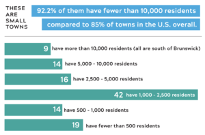
These are small towns. 92.2% of them have fewer than 10,000 residents compared to 85% of towns in the U.S. overall.
Aging demographics: 91 communities have a median age above the state average.
Income and self-employment. The Maine coast and islands have income levels similar to the state as a whole, but are distinguished by high levels of self-employment, especially in some of the smallest communities on the islands and Downeast.
- In Maine, 9% of earnings come from self-employment income.
- On the coast and islands, 19% comes from self-employment.
- 87 island and coastal communities are above the state average for self-employment.

ECONOMIC IMPACT OF LOBSTER
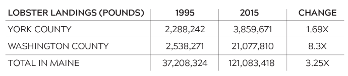
Lobster-landed pounds and value have increased in recent decades throughout the state and the percent of residents working in the lobster fishery is now very high in some communities. Lobster landings have increased throughout the state, but have increased the most in eastern Maine. York County is the southernmost in the state, Washington County is the easternmost.

ECONOMIC IMPACT OF FISHERIES & AQUACULTURE
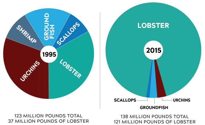
While lobster has increased in landings and value, other fisheries have decreased. The combined value of five of Maine’s wild caught fisheries in 1995 was $180 million. By 2015, it had increased to $512 million, but $495 million of this was from lobster. The increased percentage of fisheries landings from lobster has created concerns about economic resilience and an interest in diversifying marine livelihoods. Aquaculture and some wild caught fisheries provide viable opportunities.
BROADBAND ACCESSIBILITY & USAGE
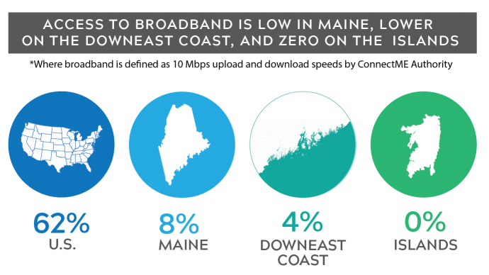
Broadband is critical infrastructure for local economic development, K-12 education, adult education & professional development, home-based healthcare, eldercare, community social engagement, and e-government. Access to broadband is currently low in Maine, lower on the downeast coast and zero on the islands, where geographic isolation arguably makes digital connectivity even more important. Maine businesses stand to gain dramatically by increasing the use of websites, mobile-friendly information and the internet in general for marketing and sales.
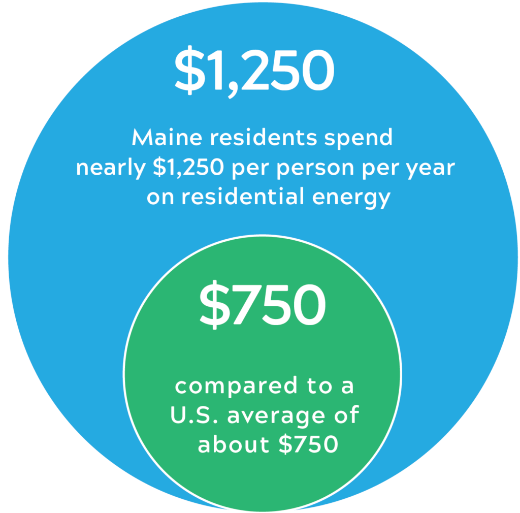
ENERGY & HOME HEATING
Mainers spend more on energy for their homes relative to GDP than residents of any other state in the country. Maine has some of the oldest housing stock in the nation and a high reliance on heating oil.
By working with partners to better understand and confront their unique energy challenges, coastal and island homeowners, businesses, and municipalities can work to reduce the cost of energy by leveraging community-based, nationally relevant models that increase energy efficiency and renewable energy options.
For examples of the Island Institute’s community energy work on projects and initiatives of all scales, visit our What Works Solutions Library.
HOUSING AVAILABILITY & AFFORDABILITY
At 16.5%, Maine has the highest percentage of seasonal homes in the U.S. There are 16 communities along the coast that have less than 50% of their housing units available for year-round residents—11 of these are islands. High rates of seasonal home ownership make it difficult for working families to find an affordable place to live.
EDUCATION
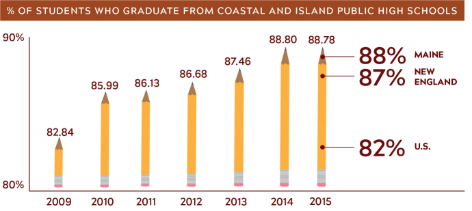
Students from the 120 island and coastal communities attend 44 public high schools: 41 on the mainland and 3 on islands. These are mostly small schools, which can bring advantages, like small class sizes and individual attention. Enrollment at most schools has been declining in recent years in line with demographic shifts. At the same time, graduation rates at most schools have been increasing.
FISHERIES & THE ENVIRONMENT
The lobster fishery in Maine is at record levels and is considered sustainable. The fishery has undergone a major shift over the last 40 years and is projected to continue changing in the future as water temperatures rise. As waters off the Maine coast continue to warm in future decades, conditions will likely be less hospitable for lobsters. While lobster is booming, almost all other fisheries are not. Between 1985 and 2005, the economic diversity of marine resources harvested in Maine declined 70%. This makes our fisheries communities highly vulnerable to any environmental changes that impact lobster.
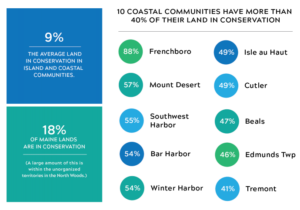
CONSERVED LAND
Land in conservation includes land owned by local municipalities, the state of Maine, the federal government, and non-governmental organizations, including local land trusts. Land is conserved for many reasons, including environmental protection, recreation, farming, forestry, working waterfront, or other uses, such as protecting public drinking-water sources.


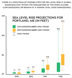
SEA LEVEL RISE & WARMING
Global sea level has risen by about 8 inches since reliable record keeping began in 1880. On average, sea levels are projected to rise another one to four feet globally by 2100, but sea level change will vary regionally. (2014 U.S. National Climate Change Assessment)
A sea level rise of two feet, without any changes in storms, would more than triple the frequency of dangerous coastal flooding throughout most of the Northeast. In Maine, a sea level rise of one foot will mean that the 10-year storm of the 21st century will cause the same damage that the 100-year storm caused during the 20th century.
BETWEEN 2004-2013, THE GULF OF MAINE WARMED 2°C, A RATE FASTER THAN 99.9% OF THE GLOBAL OCEAN
ADDITIONAL RESOURCES
Please see the following links for a comprehensive breakdown of town-specific data included in this publication.
QUESTIONS OR FEEDBACK?
If you have additional questions or feedback regarding Waypoints, we’d love to hear from you!
Click here to complete a brief survey about the publication. Your responses will allow us to answer any questions you have and tailor future editions of the report to ensure they always represent the interests and needs of our island and coastal communities.
Thank you in advance for your help!
