AT A GLANCE | BROADBAND
SEA LEVEL RISE | CO2 EMISSIONS
HOME HEATING | DOMESTIC TRADE
INTERNATIONAL TRADE
LOBSTER | OCEAN TRAFFIC
WORKING WATERFRONT
NONPROFITS
Waypoints: Connect
DOWNLOAD THE FULL PUBLICATION HERE (PDF)
The Island Institute’s Waypoints: Community Indicators series uses compelling, often never-before-seen data to communicate the character of our communities along with the challenges and opportunities before us. In Waypoints: Connect we set out to better understand the status of Maine’s coastal infrastructure systems, with a focus on the topics where we see local and state leaders grappling with change. We looked at data that are central to our physical, economic, and civic infrastructure to consider how coastal communities are connected to resources that help them thrive.
Key takeaways include:
-
Change is constant and unpredictable: Species shifts impact where fishing activity takes place. Changes in trade policy alter where goods are exported. Managing the unknowns when planning for infrastructure upgrades can be challenging, especially for small communities.
-
Yankee ingenuity matters: One-third of the coast lacks a strong economic case to build out 21st century internet service, yet communities are utilizing local financing options and public-private partnerships to get the job done. Creativity and resourcefulness are key to meeting infrastructure needs.
-
Regional thinking is required: The state of infrastructure in one community often has implications for those surrounding it. Regional collaboration can help unlock more durable solutions.
-
Infrastructure improvements are not monolithic: Progress can be made incrementally to drive towards a larger shift. Programs that direct investment in sustainable options in heating, waterfront protections, and broadband are moving the needle on the coast of Maine.
Waypoints are defined as points that “indicate a change in direction, speed, or altitude.” We hope that this edition helps communities along the coast of Maine make informed decisions on where to head from here.
 COASTAL MAINE AT A GLANCE
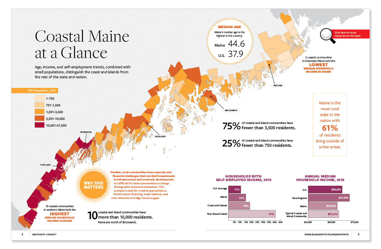
Age, income, and self-employment trends, combined with small populations, distinguish the coast and islands from the rest of the state and nation.
Many of the spreads in Waypoints: Connect rely on census data for background information or normalization. Included in this spreadsheet is the census data used in the publication by county subdivision. This includes: Total Population, Total Housing Units, Total Households, Median Household Income, Self-Employment Income, Median Age, Rural Population, Total Occupied Housing Units, and House Heating Fuels.
BROADBAND | ECONOMIC FEASIBILITY
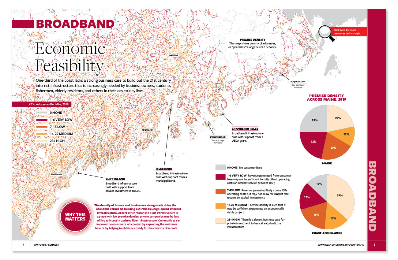
One-third of the coast lacks a strong business case to build out the 21st century internet infrastructure that is increasingly needed by business owners, students, fishermen, elderly residents, and others in their day-to-day lives.
Additional data and resources:
- The process for obtaining broadband varies from community to community—from different financial structures to various ownership models. Our team has developed a tailored approach for working with each community as they define their priorities and implement their own unique path for bringing broadband to their towns and cities. Learn more about the Community-Driven Broadband Process here.
- Point Density Map of the State of Maine as it relates to the economic feasibility of broadband. The map displays a point density analysis (not speed or coverage), an analysis that shows density of premises along the road network which is related to the economic feasibility of building broadband infrastructure.
- Maine E911 Roads from the Maine Geolibrary is a spatial file of road centerlines complied by the State of Maine Emergency Communications Bureau for the Next Generation 911 project in Maine. Files can be downloaded as shapefiles, KML, or spreadsheets for use in geographic information systems or data processing software.
- Maine E911 Addresses from the Maine Geolibrary is a spatial file of address points of addressable structures and other landmark locations complied by the State of Maine Emergency Communications Bureau for the Next Generation 911 project in Maine. Files can be downloaded as shapefiles, KML, or spreadsheets for use in geographic information systems or data processing software.
TRANSPORTATION | SEA LEVEL RISE VULNERABILITY
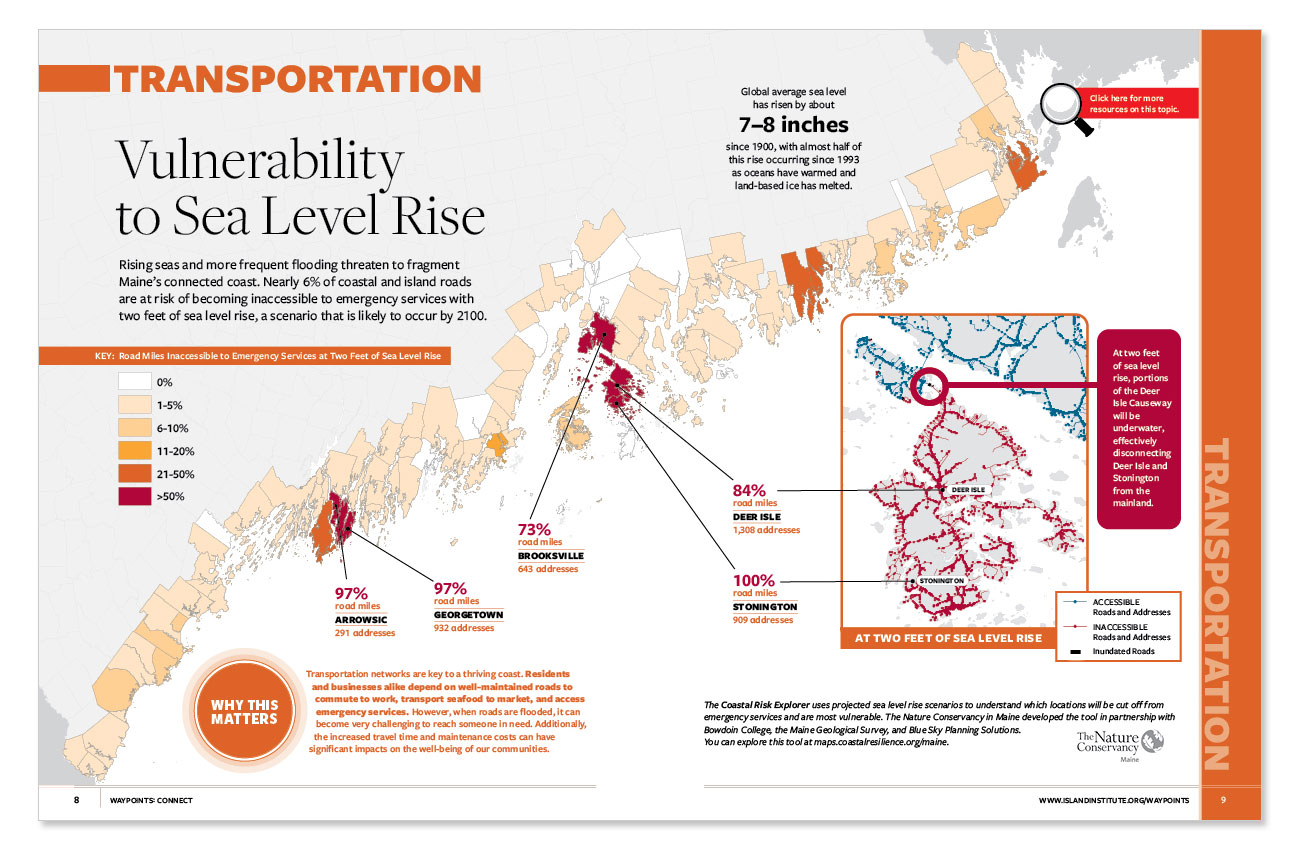
Rising seas and more frequent flooding threaten to fragment Maine’s connected coast. Nearly 6% of coastal and island roads are at risk of becoming inaccessible to emergency services with two feet of sea level rise, a scenario that is likely to occur by 2100.
Additional data and resources:
- The Coastal Risk Explorer is an interactive map which shows the roads that will be inundated and roads that will become inaccessible at different scenarios of sea level rise. When roads become inaccessible this makes it difficult for emergency responders to get to those in need and is related to the social vulnerability of the population living in the area. Use the tool to explore communities along the coast of Maine under different sea level rise scenarios and the relationship between inaccessibility and social vulnerability. The tool was developed by The Nature Conservancy of Maine for the Coastal Risk Explorer tool with Bowdoin College, the Maine Geological Survey, and Blue Sky Planning.
- Fourth National Climate Assessment is a report explaining the science behind climate change and its impacts in the United States. For more information on the amount of global average sea level rise, check out Chapter 2: Our Changing Climate, Key Message 4.
- Vinalhaven’s “The Cost of Sea Level Rise: Economic Impact Analysis,” a 2019 study commissioned by the Island Institute to understand the economic impacts of sea level rise to communities along the coast of Maine. This study focused on three communities and is sharing the report as interactive story maps. The first community completed was Vinalhaven. Stonington and Scarborough will be shared upon completion of those sections of work.
TRANSPORTATION | CO₂ EMISSIONS
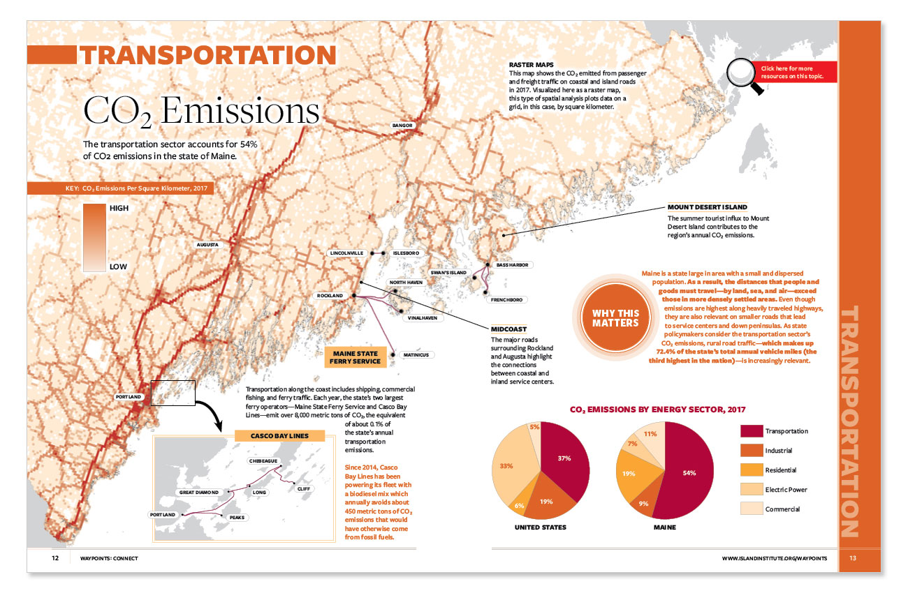
Since this publication was released, Maine has adopted a Climate Action Plan which sets a goal of reducing greenhouse gas emissions by 45% by 2030 and 80% by 2050. Fifty-four percent of CO2 emissions come from transportation in the state of Maine.
Additional data and resources:
- CO2 Emissions in the State of Maine is a statewide map of DARTE Annual On-Road Emissions data showing the CO2 emissions throughout the state based on the roadway-level vehicle traffic. As expected, the most heavily traveled areas are the areas with highest concentrations of CO2 emissions. The map highlights connections between service centers like Augusta and Rockland.
- DARTE Annual On-road CO2 Emissions is a raster dataset compiled in the Database of Road Transportation Emissions (DARTE) that provides a 1-km resolution inventory of annual on-road CO2 emissions for the conterminous US based on roadway-level vehicle traffic data an state-specific emissions factors for multiple vehicle types.
- Maine Public Roads from the Maine Geolibrary is a spatial file of road centerlines created by the Maine Department of Transportation and includes Maine State Ferry Service routes. The data set also includes attribution of traffic volumes, priorities, and more.
- State of Maine Total Emissions is an annual report of state carbon dioxide emissions by fuel and energy sector in the form of Excel spreadsheets. Data is compiled by the U.S. Energy Information Administration.
- Percent of Rural Vehicle Miles Traveled: A map showing the rural share of vehicle miles traveled from the US Department of Energy, Office of Energy Efficiency and Renewable Energy.
ENERGY | HOME HEATING
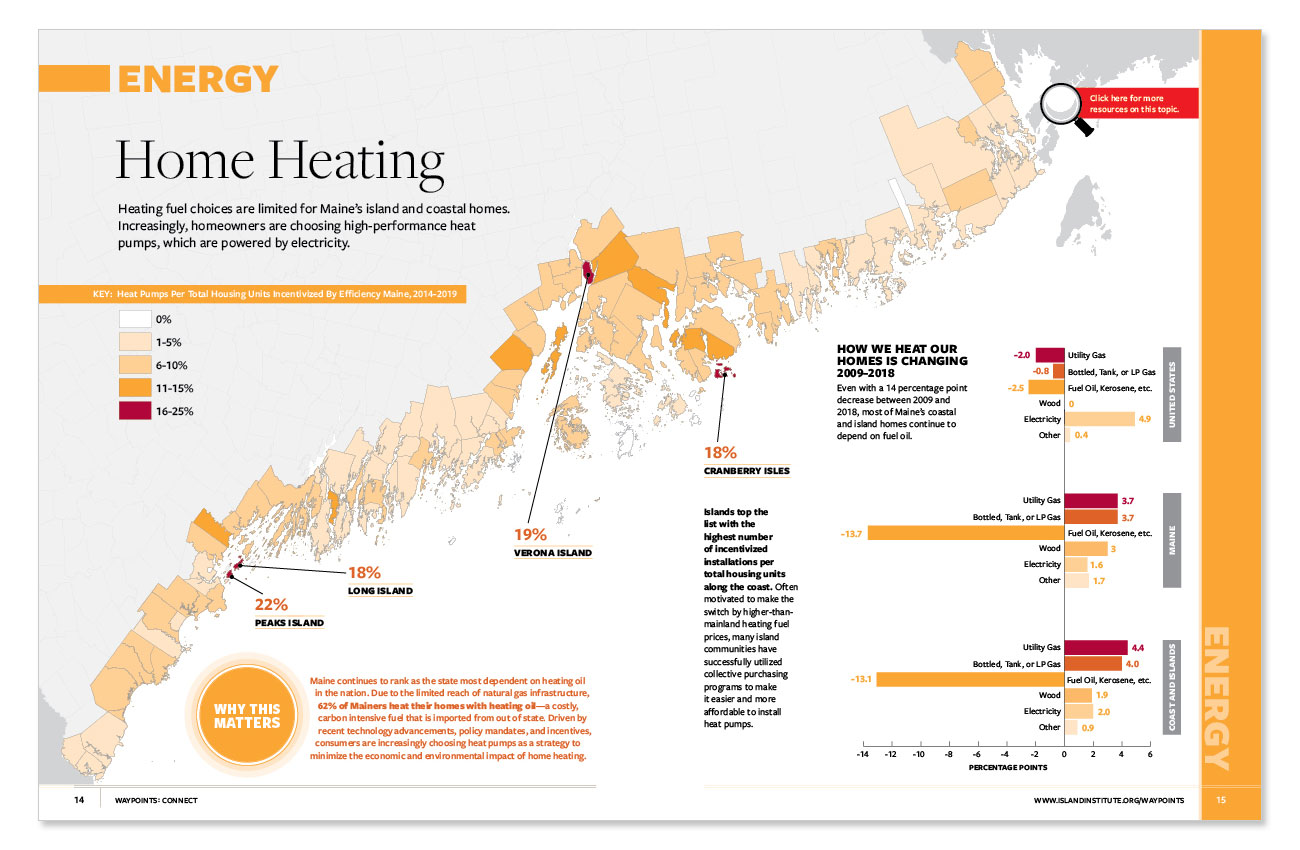
Heating fuel choices are limited for Maine’s island and coastal homes. Increasingly, homeowners are choosing high-performance heat pumps, which are powered by electricity.
Additional data and resources:
- Heat Pumps Per Total Housing Units: Efficiency Maine is a quasi-state agency set up as a trust to independently administer programs to improve energy efficiency in Maine. One of the programs is to provide incentives for installing heat pumps in housing units. This map shows the number of heat pumps installed using the Efficiency Maine Incentives program by the number of total housing units in each town in Maine.
TRADE | DOMESTIC CONNECTIVITY
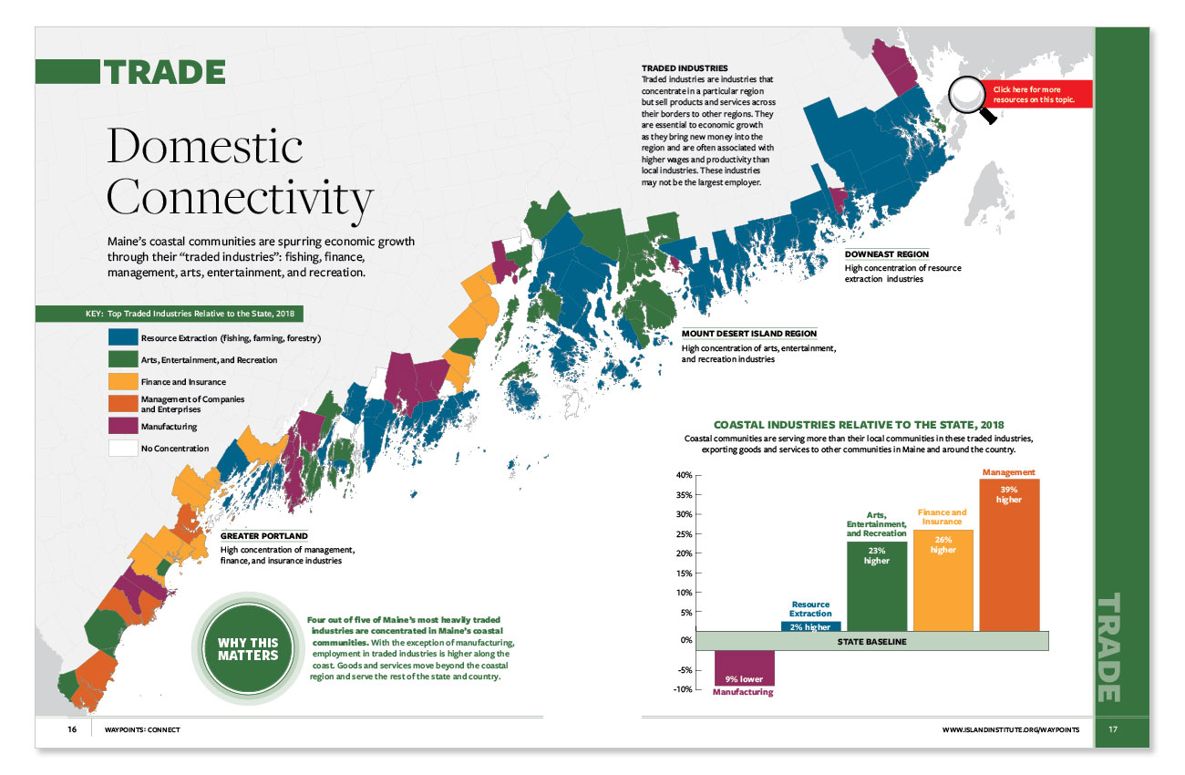
Maine’s coastal communities are spurring economic growth through their “traded industries”: fishing, finance, management, arts, entertainment, and recreation.
Additional data and resources:
- Traded Industries are defined and categorized by Delgada et al. “Categorization of Traded and Local Industries in the US Economy” in the US Clusters Project. Traded industries are industries that are concentrated in a geographic area and service a wider area. This is juxtaposed with local industries which are those that are servicing a local area. Use this link to learn more.
TRADE | INTERNATIONAL CONNECTIVITY
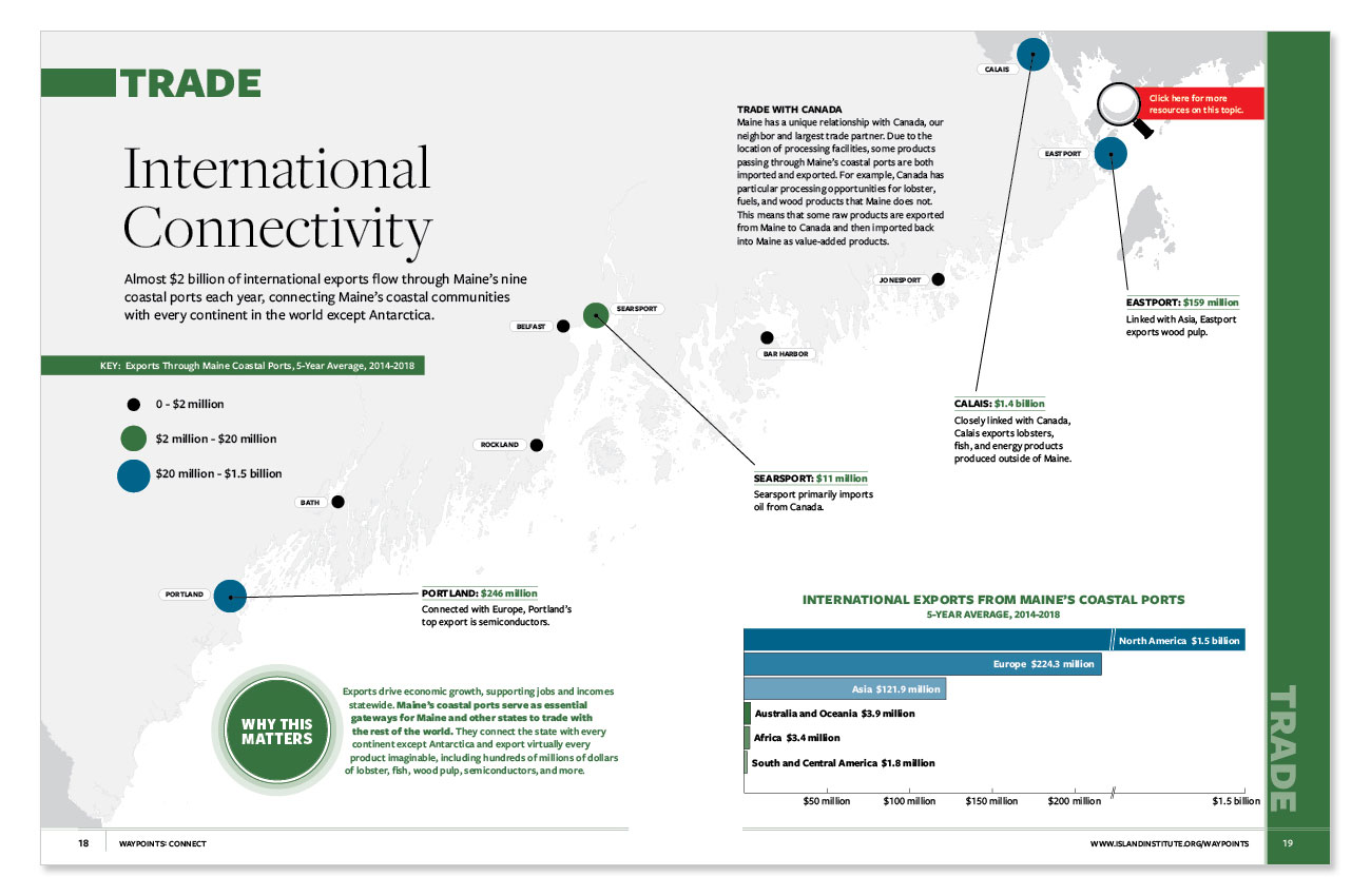
Almost $2 billion of international exports flow through Maine’s nine coastal ports each year, connecting Maine’s coastal communities with every continent in the world except Antarctica.
Additional data and resources:
- USA Trade® Online tool is a source of trade statistics provided by the U.S. Census Bureau. The tool allows users to create custom reports and charts from U.S. international trade data and is used by a variety of industries to perform many different queries to inform advertising, market growth, and much more.
TRADE | LOBSTER IMPORTS AND EXPORTS
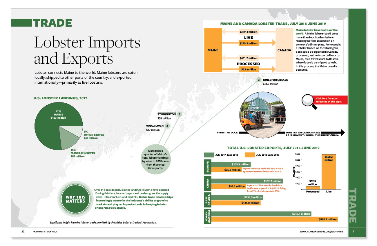
Lobster connects Maine to the world. Maine lobsters are eaten locally, shipped to other parts of the country, and exported internationally—primarily as live lobsters.
Additional data and resources:
- Maine Department of Marine Resources Lobster Landings Viewer is an interactive tool providing information about lobster landings in Maine ports by value and pounds from 2008 to the present.
- Fisheries of the United States is a report published each year by National Oceanic and Atmospheric Administration National Marine Fisheries Service presents fisheries statistics on recreational and commercial fisheries by species.
- USA Trade® Online tool is a source of trade statistics provided by the U.S. Census Bureau. The tool allows users to create custom reports and charts from U.S. international trade data and is used by a variety of industries to perform many different tasks. Using the state export data (origin of movements) specific commodities, like lobster, can be tracked.
WORKING WATERFRONTS | OCEAN TRAFFIC
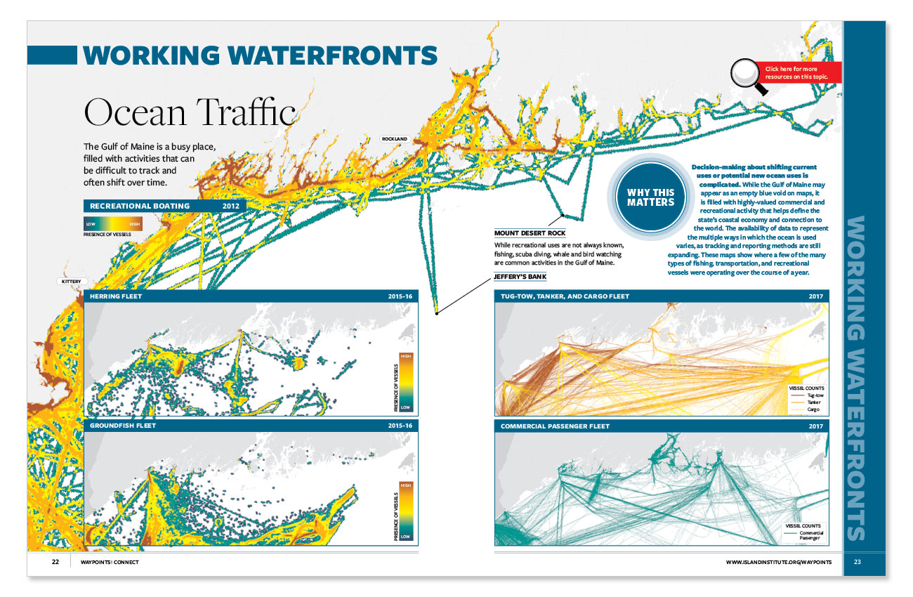
The Gulf of Maine is a busy place, filled with activities that can be difficult to track and often shift over time.
Additional data and resources:
- Northeast Ocean Data Portal is an interactive tool that provides data focused on the ocean ecosystem and ocean-related human activities. It includes data on marine transportation, energy and infrastructure, recreation, commercial fishing, aquaculture, and much more. It is used to aid decision-making in the northeast region of the United States surrounding ocean planning.
WORKING WATERFRONTS | PROTECTIONS
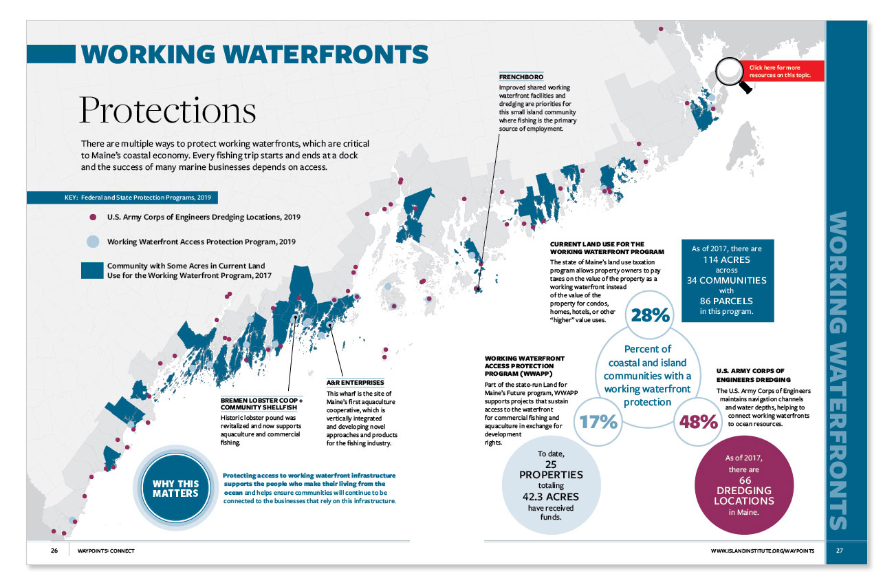
There are multiple ways to protect working waterfronts, which are critical to Maine’s coastal economy. Every fishing trip starts and ends at a dock and the success of many marine businesses depends on access.
Additional data and resources:
- Working Waterfront Access Protection Program (WWAPP) currently has 25 properties (listed in the pdf) in this program that support projects that sustain access to the waterfront for commercial fishing and aquaculture in exchange for development rights. It is administered by the Land for Maine’s Future.
- Current Land Use for Working Waterfront a program administered by the State of Maine, Department of Administrative and Financial Services, Maine Revenue Services. The program is available to property owners who show they meet the requirements of the state and results in a property assessed at the value of its current use instead of the best and highest use. In this case the property is assessed as working waterfront property and not for its potential as property developed into hotels, resorts, or other higher value uses.
- U.S. Army Corp of Engineers Navigation Projects are detailed in this website showing the 66 locations maintained by the U.S. Army Corp of Engineers in Maine with site maps, drawings, and dates where available.
CIVIC INFRASTRUCTURE | NONPROFITS
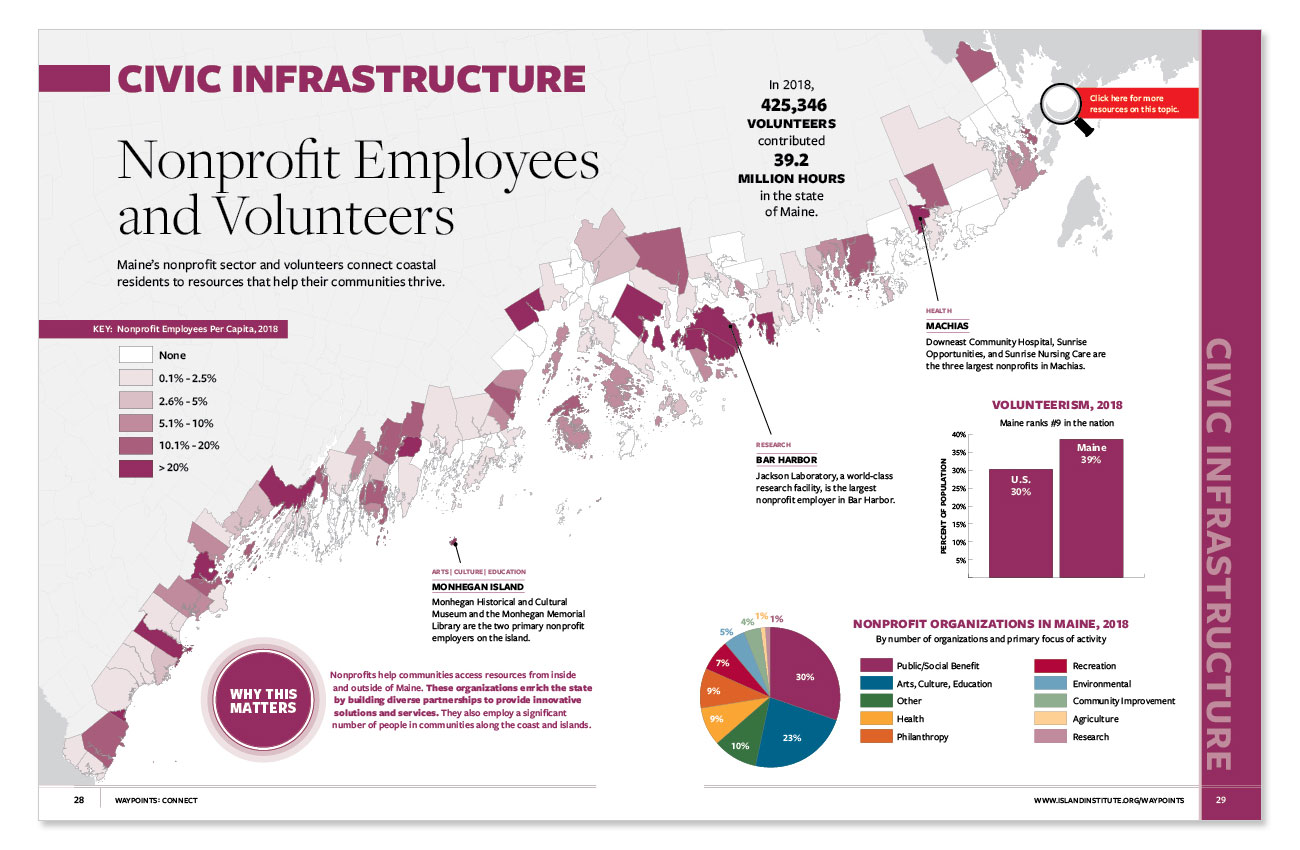
Maine’s nonprofit sector and volunteers connect coastal residents to resources that help their communities thrive.
Additional data and resources:
- Exempt Organizations Business Master File Extract (EO BMF) is a downloadable data set from the U.S. Internal Revenue Services, Charities and Nonprofits. It is a cumulative file of all tax-exempt organizations in the United States and can be extracted by region or state.
- Statistics of Income Tax Stats-Annual Extract of Tax-Exempt Organization Financial Data is a downloadable data set from the U.S. Internal Revenue Services, Statistical Information Services. Financial data is compiled from tax-exempt organizations filing forms 990, 990-EZ, and 990-PF.
- Volunteering in America is a report maintained by the Corporation for National and Community Service which follows trends and data on volunteer rates in the United States. Each year it ranks the 50 States by volunteerism and creates a state profile for each state based on number of volunteers, number of volunteer hours, and more. Here is the Maine Profile of Volunteerism.
