
When people think about coastal erosion, they often picture waves crashing into the shore. But after spending the past year walking shorelines across Casco Bay with my colleague, ShoreCorps Steward Emma Polhemus, I’ve learned that it’s often more complicated than that. In addition to wave action, rainwater running down a road, groundwater moving through a bluff, foot traffic, and vegetation can all play a role. What’s more, several of these things are often happening at once.
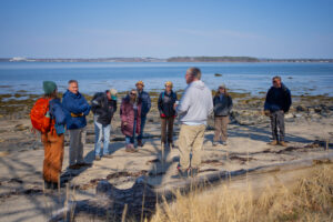
From spring 2025 to spring 2026, Emma worked alongside me, other Island Institute staff, and community partners to assess erosion at public and private properties on Chebeague, Cliff, Great Diamond, Little Diamond, Peaks, and Long Island. Our aim was to support communities in better understanding what was happening along their shorelines and how they can respond. Emma led the assessments using the Maine Department of Environmental Protection’s OUR SHORE tool. At each site, she looked at shoreline characteristics including the height and shape of the bank, how water moved across and through the site, how much vegetation was present, and the role of waves and storms. Importantly, this assessment isn’t an engineering plan. Instead, it gives communities and property owners a better understanding of what may be causing erosion,some options to consider, and a place to start planning their response.
One thing that stood out to me from Emma’s work is that erosion doesn’t always start at the water’s edge. For example, at Ferry Beach on Peaks Island, rainwater running down a footpath and alongside a set of stairs was washing away soil. Emma recommended ways to slow the water, cover bare soil, and replant the area with native vegetation. At the VFW Hall on Long Island, groundwater was also part of the problem. Dark, wet soil showed that water within the bluff was likely weakening it, while runoff had created a gully beneath the stairs leading to the shore. In other words, sometimes you need to look uphill to understand what is happening at the shoreline.
The assessments also made clear that there isn’t one solution for coastal erosion. The best response depends on the site characteristics, factors causing erosion, and what people are trying to protect. Emma’s assessments and the Island Institute community climate planning team’s work has been helping communities explore nature-based strategies (NbS), to identify a site-specific response. NbS utilizes natural systems and processes to address erosion and other coastal challenges.
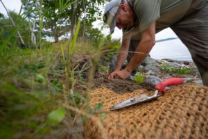
This can look different depending on the shoreline. Sometimes relatively simple changes, such as planting native vegetation, covering bare soil, redirecting runoff, or moving foot traffic can help. Other sites may benefit from protecting or restoring dunes or salt marshes. More exposed shorelines may still need structural protection, sometimes paired with vegetation or other natural materials. If nature-based strategies are new to you, Island Institute’s Nature-based Strategies 101 video offers a quick introduction to what they are and how Maine communities are using them.
On Great Diamond and Little Diamond islands, for example, Emma identified places where adding native vegetation and strengthening shoreline buffers could help hold soil in place and manage water moving toward the shore. In other places, doing less may be an option. At Division Point on Chebeague Island, there are no buildings or critical infrastructure at the top of the bluff. Emma’s assessment notes that one option is to allow the bluff to continue its natural cycle of erosion and reshaping over time. That can be a difficult choice, but it is part of the larger conversation communities are having about what they can protect, what may continue to change, and where it makes sense to intervene.
This exploration of NbS on Maine’s coast builds on years of work led by Casco Bay island communities. Long Island residents planted beach grass at Fowler’s Beach in 2022. In 2023, island leaders on Great Diamond Island planned and led boat tours to visit shoreline projects and learn from one another. From 2024 through 2026, communities including Little Diamond, Great Diamond, Long, and Chebeague Islands continued sharing what they were learning through an online symposium, the development of a toolkit, and several island field trips. Island Institute helped bring people together, connect communities with technical resources, and support ideas coming from the islands themselves. The assessments were a natural next step, that is, taking some of that shared learning and applying it to specific places.
Every shoreline is different, but you may recognize a problem that looks a lot like your own.
Emma’s reports give each community a record of what she saw, what may be contributing to erosion, and what options could be explored. But we also think they can be useful beyond the six islands where the assessments took place. That’s why these reports are available on Island Institute’s website. We hope other island and coastal communities, municipal leaders, and property owners can use them as examples. Every shoreline is different, but you may recognize a problem that looks a lot like your own.
You also don’t need to have one of Emma’s assessments to start looking more closely at your own shoreline. Maine DEP’s OUR SHORE resources include the same Quick Assessment we used for this work. Property owners and community leaders can use it to walk through their own site, think about what may be causing erosion, and identify strategies they may want to explore further. It doesn’t replace an engineer or other professional when one is needed, but it can help you know where to start and what questions to ask.
After a year of walking these sites, one thing has really stuck with me: before deciding what to do about erosion, it’s important to understand what is actually happening at a site. Look at the water, but also look uphill. Where does rainwater go? Where is the ground bare? What is growing along the shoreline? What has changed over time? Taking the time to understand those pieces can help communities and property owners make better decisions about what to do next.